Drone, Inc. - C. Synthetic Aperture Radar

In late August 1999, Sen. Pete Domenici joined Neal Blue, the CEO of General Atomics and C. Paul Robinson, the director of Lockheed Martin-operated Sandia Laboratories, at a ceremony in Albuquerque, New Mexico. They were there to unveil the Lynx, a 115-pound bright red gadget and to proclaim it the future of aerial observation.51
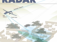
To this day, a version of the Lynx is still mounted on some Predators and Reapers. It uses “synthetic aperture radar,” a technology invented in the 1950s, that fires multiple radar beams from a moving aircraft and then captures the bounce-back to create a three dimensional image. Unlike a camera lens that is pointed straight down, SAR’s sideway-angled view can monitor a wider swathe of land. If an aircraft takes multiple pictures as it moves in a straight line, computers can then stitch together a panoramic picture of the terrain below.52 Another system, Tactical Endurance Synthetic Aperture Radar (TESAR), manufactured by Northrop Grumman, is also available as an option for the Predator.53
SAR offered the advantage of being unaffected by most bad weather. “Cameras provided good data, but they don’t work at night or in rainy, foggy and cloudy situations,” Bill Hensley, the Sandia project leader, said at the New Mexico unveiling. “Fine-resolution image SAR radar is perfect for these circumstances because it can ‘see’ in the dark and peer through clouds and fog.”
The image SAR produces looks like a clay model of terrain. It can capture objects as small as four inches in diameter over areas as wide as tens of miles. What excites the military most about modern SAR imaging is an add-on technology called “coherent change detection” that allows a computer to compare images from multiple missions and alert users to movements
or changes, such as vehicles or even a walking person.54
The most sophisticated SAR system, carried by the F-35 jet fighter, is reputed to be able to zoom in and out of a landscape on command, but is far too heavy for drones.55 Even the lightweight Lynx takes up a tenth of the Predator’s weight.
Despite those advantages, SAR suffers from several problems. First is the Lévy flight error, colloquially described as the “drunkard’s walk.” A target that moves randomly and quickly in many directions creates a smear across the image.56 A soccer game or a market would render the images unusable. For this reason, coherent change detection has a very hard time tracking many small moving objects that exist in most natural environments.
The second major problem lies with the relationship between the SAR antenna and the “inertial measurement unit” (IMU) that is supposed to calculate the drone’s position. Since SAR works sideways, when operators move the camera to improve video observation, the angle of the radar changes.
“If knowledge of radar’s relative position were exact, then the image could be formed with perfect focus, ignoring atmospheric effects,” Armin Doerry, the Sandia engineer who was one of the main developers of the Lynx, wrote in a January 2015 technical paper on SARs. “An IMU is a collection of instruments that make six independent measurements. There are at least twelve independent unknown errors that need to be corrected by an aiding scheme. Unless each error is made observable and identifiable, ambiguity exists for all others.”57
Doerry notes that GPS location does not help much in this matter since it only updates once a second and cannot provide the angle of the radar. To correct for this, an enormous amount of computing power is needed to calculate mapping in real time, or there must be many passes over an object— which defeats the idea of real-time observation.
SAR encounters another problem: scattering. In built-up urban areas or among the mountain slopes that it is required to map in countries like Afghanistan, the radar bounces back at unpredictable angles, depending on the location of the drone.
“Areas behind buildings lie in the radar shadows, and images of tall buildings can obscure other features of interest,” wrote Margaret Cheney in a 2009 paper for the Naval Postgraduate School. “There is an added difficulty that that same object will look different when viewed from different directions.”58
But it is not that SAR is imprecise or unusable. It can guide missiles and observe fixed locations to detect equipment being moved on or off a base or compound. And where it excels in the public interest is in mapping locations when an aircraft can repeatedly move in a specific direction at a specific speed. This function has enormous potential for scientific observations, from mapping the Moon to observing terrestrial glacial ice formations and landslides.59 Unfortunately for tracking moving people, SAR remains a secondary and relatively useless sensor.
< Previous • Report Index • Download Report • FAQ/Press Materials • Watch Video • Next >


